Sunday 24 February 2013

The Motte Stone Co Wicklow

                                             Above Image: The Hill path


                                         Above Image: The Bullaun on top


                                           Above Image: The metal rungs


                                     Above Image: The disused car park with
                                                          the stone in the distance

                                     Above Image: Access point from the road.


We were returning from Wexford one evening in September when I remembered this strange stone was in the area. Although there was still plenty of daylight, the sky was becoming increasingly cloudy, but we decided to detour a little just to have a look at this oddity.
The Motte Stone as it is referred to sits on top of Croneblane Ridge 800 feet above sea level and overlooks the vale of Avoca. It is a huge quartzite boulder that appears to have been deposited on the ridge by a receding glacier during the last ice age (Circa 13000BC). It measures about 9 feet in diameter and roughly the same in height. All sorts of legends surround this stone ranging from it being a giant's hurling stone (Finn McCumhail, the legendary Irish giant) to being a sacred stone. Some people have claimed to have seen light surrounding it, although it being formed of quartzite and with its prominent height it could be that it is reflective. Another legend is that any person putting a question to it will receive an answer!
Truthfully it is very mysterious and there is evidence it was once incorporated into a Motte and Bailey structure for defence hence giving it it's name. This ancient structure has long since disappeared but the stone still remains proud. With all of these tales why wouldn't you want to have a closer look.
By the time we were in the vicinity the cloud had thickened and a misty drizzle began but we were not deterred. Sadly with these conditions we were unlikely to gaze at the view of five counties that can be had on a clear day, but no mind the mist would only add to the overall mystery of the stone.
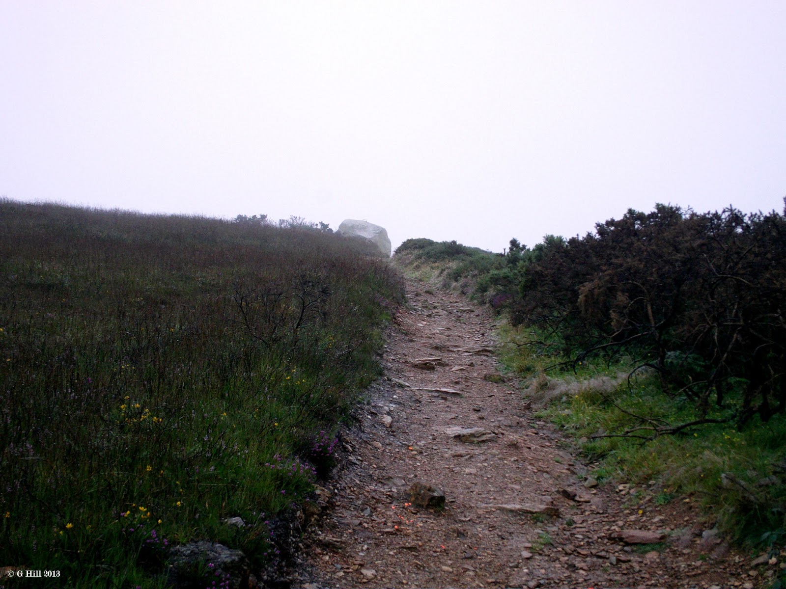
We had to take a few turns through country back roads until we found the narrow isolated lane that led to the site. A few years ago the local authority had provided a car park for visitors but due to some issues with rubbish dumping and the actual defacing of the stone with paint it was finally closed. Now you have to park on the somewhat muddy lane and trek through the overgrown car park before you reach the short trail to the summit. It is not a long walk, perhaps 8-10 minutes and not very steep either but all the time you have the stone in view getting larger as you approach.
The mist was really coming down at this point but having made the decision to continue we were determined to reach the stone. Finally on arrival at the summit you will find it all worthwhile as this is truly an amazing curiosity. It is amazing to think that this stone has stood here throughout history long before any people had migrated to this country around 7000BC. Awe inspiring.
On the summit the stone stands tall overlooking an area strewn with smaller rocks, no doubt other debris left by the glacier. A set of metal bars have been hammered into it on one side to provide a rudimentary ladder enabling you to climb up on top of it. On doing so we were surprised to find a cup shaped indent carved out of the top to collect rainwater which if legend has it that this was a sacred stone then the water would have been dispensed for healing purposes. This in effect makes The Motte Stone probably the largest Bullaun stone in the country. Even in the mist it was evident that this held a significant view and it is not surprising that a fort had been built around it in the past.
We spent a little more time there until the misty rain became heavier so it was time to leave, but we will definitely return here on a clearer day.
To find The Motte Stone head south on the M11/N11 Dublin to Wexford road and after Wicklow watch out for "The Tap" Pub on your right. A short distance later there is a turn onto the R754 beside another pub called "Lil Doyles" Take this right turn which leads to the village of Redcross. On the main street you will see a right hand turn pointing towards Avoca. Follow this road which extends uphill until you come to a five way junction. One of the roads on your right has a sign pointing the way to the Motte Stone. Turn down this road and continue until you come to a small crossroads with another sign for the Stone pointing left. Down this narrow left turn you will pass Conary Church and then you will reach a fork in the road. Take the right hand narrower fork and drive until you spot the abandoned car park on your left. You will see the Motte Stone in the distance. You can park here by the roadside but leave room for anyone who might need to pass. Access to the old car park can be found through a small gap in the brushy overgrowth.

 RETURN VISIT APRIL 2015


As promised we made a return here on a much more clearer day and what magnificent views from the stone's vantage point as you can see from above. Really, really worth your time on a sunny day to spend the few minutes it takes to walk up to this curiosity.

Saturday 16 February 2013

Causetown Castle Co Meath


                                  Above Image: The stump of a long gone tower


                                        Above 2 Images: Some interior shots


Standing lonely in a field just off the Athboy to Delvin road stands the remains of Causetown Castle (or Lisclogher, depending on which town land you think its in). This 16th century Z-plan tower house has been reduced today to just one storey. It has two towers standing on the North West and South East corners. The smaller South east remains most intact and sports a garderobe turret. The greatly reduced North East tower still contains remains of a stairs. The tower house was the abode of the Dowdall family a well known  family who would have come to Ireland around Norman times and gained a foothold in the area.in the area. There is little more information about the Castle but it most likely besieged in either the Cromwellian invasion or the subsequent rebellion in the 1600's.
Today this shell, visible from the road, is in a pretty poor state but it still has a striking aspect to it that makes you want to stop and explore further.
The road alongside is quite narrow but it is possible to park at large field gates outside. The Castle lies on farmland but we were in luck the day we stopped as the padlock on the gate was undone so we made an entrance and trekked across the field which was quite boggy from a lot of previous rainfall in the prior week. This day though was dry and bright but the field was still swampy in places. It looks now with the added fencing to the outside that it is being utilised as a byre for cows and it is quite muddy around the entrance door. Within there is not much to see except the very solid looking barrel vaulted ceiling on the ground floor otherwise it appeared to be actually raining inside as water still ran down the walls and ceiling cracks from previous rainfall. Certainly the outer aspect is much more interesting.
Boggy or not it was great to get up close to this ruin and its well worth a stop especially if the weather has been dry and you don't have to avoid sinking in the mud!
To find Causetown Castle, take the M3 Dublin to Cavan Motorway and exit at Junction 9.Take the N51 towards Athboy and once through the town drive for approximately 4km and you will eventually spot the Castle in a field on your right, Drive slowly as you will need to park at the field gate outside.

Friday 1 February 2013

Castlejordan Castle Co Meath


                                       Above Image: The two flanking Towers


                                           Image Below: The Stair Turret


We located these ruins by pure chance.We were in the area looking for Kinnefad Castle (See earlier post here) and I stopped to get some directions from a local man busy mowing his lawn. In talking he mentioned the existence of Castlejordan so we went to take a look on our way.
There is very little information regarding these ruins but what I could uncover is that a young man named Jordan De Courcy, in exile in Exeter after his father's death, returned to Ireland in the early 13th century and built a fortress here. We can only assume that these ruins are what remains. It later became the ancestral home of the Giffords. In 1661 Thomas Gifford became the first Baronet although the Baronetcy is said to have ended with his demise a year later. There are records of some later Giffords which include an attack on the Castle against Sir J Gifford and Lady Jepson by rebels in 1642, but it all becomes rather sketchy after that.
The ruins sit beside a bridge on the River Mongagh. When we located them we found they are mostly on private land with a large modern house adjacent. The lane way leading to the gates of the house affords a view of two towers, one of which is now covered in ivy. We managed to cross over the grassy area which was only cordoned off by some twine and have a closer look without infringing on the house which squarely says private property and in doing so discovered a doorway that led to what looks like the remains of a bawn. Beyond this but fenced off is a curious circular tower almost resembling the Wonderful Barn
in Kildare (see previous post here) This appears to be a turret stairs of maybe four storeys and although looked interesting was unfortunately inaccessible.
While there is not much more of the ruins left, what remain are spread over a considerable area prompting the thought that they are all part of the same structure rather than separate entities, but this is not entirely a   certainty. If they are then Castlejordan must have been a formidable place in its time.
Unfortunately the two flanking towers look as if they will disappear soon under a coating of ivy. It would be nice to see them both cleared in time to reveal the impressive ruins that lie underneath.
We didn't stay too long here as we felt we were possibly trespassing and we had other Castles to see in the area but it's certainly worth a stop at Castlejordan if you happen to be passing.
To find the ruins take the M6 motorway and exit at junction 2 taking the road to Ballinabrackey. Drive for approx 7.5km until you reach a small T-Junction. Turn right and drive for a further 200m until you see a signposted right hand turn for Castlejordan. Take the turn and cross the stone bridge and you will spot the ruins a little down the road on your left. Parking on the roadside is possible.