Saturday 21 September 2013

Newcastle Lyons Castle Co Dublin

                                  Above Image: The Northern and Eastern walls


                                        Above Image: The corner projection


Standing a bit forlorn looking behind a hedgerow are the remains of Newcastle Lyons Castle. This L-Plan tower house was once one of six castles around Newcastle, a village that in its time became both a feudal barony and a pocket borough. The village came under attack by the Earl of Ormonde in 1642 and was somewhat destroyed. No doubt this castle also suffered damage as a result. It's history is vague. It might be one of the £10 castles that were commissioned to defend the pale but we cant really be sure. The only other remaining tower in the village is the one attached to St Finian's church built circa 1400. Adjacent to the church is a Motte which originally housed a Norman Motte & Bailey the earliest fortification in the village. While St Finian's tower is in quite good condition its cousin across the road is however in a dilapidated state and diminished to only two storeys. This tower house was more than likely twice the height originally and it measures approx. 4 metres square at its base.
We only discovered this sadly neglected ruin as we were leaving the village when I spotted it poking above a hedgerow! It is situated on the edge of a farm field with a field gate at the roadside. There were no prohibitive signs so we jumped the gate to take a closer look. Like other castles of its type situated on farmland which find themselves sometimes being utilised as Cattle byres this one appears to be functioning as a tyre byre! It is quite overgrown in places inhibiting any further access but its projected wall on the North side gives what remains an interesting aspect. I don't think that much of this castle will be visible in another 100 years. It will have either crumbled further in on itself or the remains engulfed in ivy.
There is not much further to say other than if you happen to find yourself in Newcastle you could stop and take a look at this lonely old ruin, otherwise it is probably not worth a special trip. I do think it is important though to document what we can of these type of ruins while they are sill standing and accessible so I will on my part continue to do so whenever I can.
To find the ruins take the Junction 4 exit of the N7 motorway and follow the sign for the R120 to Newcastle. Once on the R120 you will pass through 4 roundabouts before you reach the main street of the village. Near the far end of the main street the road bends sharply to the left at a junction with the R405. Follow the left hand bend and about 100 metres along you will spot the castle above the hedgerow on your left. There is a field gate here and you can park alongside.

Saturday 14 September 2013

Old Killybegs Demesne Church Co Kildare


                      Above Image: The Field gate (Entrance through gap on right)

                                           Above Image: The entrance stile


                                      Above 2 Images: close ups of the belfry


                                      Above Image: The East facing window


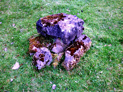
                           Above Image: Curious stone formation near South wall


This interesting old medieval parish Church lies a little off the beaten path.As with other parish Churches of the time its use would have diminished after the reformation although the graveyard surrounding it contains stones dating from the 18th to the 20th centuries some of which are weather worn to nearly ground level. It was not uncommon for the grounds of these old Churches to be used as burial places as the ground was already consecrated.
Hunting down old ruins like this is half of the enjoyment of the experience. This particular one is tucked away down a long country lane leading from a leafy part of the Grand Canal and is surrounded by pastureland. At the end of the lane is what appears to be a recently abandoned house and the entrance to a private estate, but a field gate on the left gives access to a farm track. A few metres down this track on the right you will find the Southern boundary wall for the ruins. They are accessed by a stile adjacent to a locked metal gate. The grounds appear to be kept in a reasonable state unlike some sites where you have to wade through waist high raptor grass and nettles.
The Church is situated on slightly elevated ground with a low bank and surrounding ditch. The Western and Eastern gables still stand to full height but the belfry on top of the West wall is crumbling badly so much so that I felt that if I knocked against the wall with any force the belfry would come tumbling down!
The Northern and Eastern walls have suffered badly and are really only partially standing on the Eastern end with debris of the rest of the walls strewn about. Still, the structure has an interestring aspect to it and seems to be a bit larger than the normal ruins of this type, so it would be quite interesting to get some more info on its history. All I can discover myself at this time is that the demesne on which the ruins lie were one part of Killybegs estate owned by the Dongans of Castletown. After the Cromwellian invasion the lands were held by Nathaniel Staughton but over time were restored to the Dongans and subsequently the Fitzgerald family . The house was roofless by the late 1950's and demolished some time later. There is no mention of the Church.
It was very quiet here on our visit only the distant Church bells in Clane wafting through the air. Its an isolated spot so we didn't expect to meet anybody and in fact we didn't.
To find the ruins take the Millicent Rd out of Clane Co Kildare, this is the road adjacent to the ALDI store. Keep on the road for approx. 3KM (You will pass Millicent Golf Club along the way) and drive until you cross a stone bridge spanning the Grand Canal. Take the first right turn after the bridge and almost immediately the next right turn. Follow this road until you reach another stone bridge. Cross over the bridge and turn left onto the road that runs parallel with the canal. Continue on until you have passed four house gate entrances and you will reach a lane way on your right that runs between two houses. At the end of this lane is a field gate on the left hand side. You can park here and the ruins are through the gate a little down on the right.

Thursday 5 September 2013

Ferrycarrig Castle Co Wexford


                          Above Image: the Castle and Memorial tower to the right

                                      Above Image: The steps to the Castle

                                  Above Image: View from the Castle entrance


                                   Above Image: View from the South bank


When Robert Fitz-Stephen landed in Bannow bay in 1169 as one of the leaders of the Norman invasion, his efforts in command and conquer were rewarded by way of lands granted to him that stretched from Bannow to Wexford Town. At the mouth of the Slaney river he built a stronghold called Carrick and this was thought to be Ferrycarrig castle, but in fact according to recent archaeological investigation his structure was on the South bank where the heritage park now stands. The present ruin of Ferrycarrig castle stands on the North bank dating to the 15th century and was constructed by the Roches a prominent family in this area whose forebears also arrived in the invasion .The Castle was designed to act as a defence for the important river ferry and other craft on the Slaney. The ferry was the only means of crossing the mouth of the river as a wooden bridge was not constructed until 1795. The Roche's eventually lost their titles in the early 1600's and their lands and possessions in the Cromwellian invasion and subsequent plantation. This would no doubt have included Ferrycarrig.
The Castle built upon a huge rock outcrop commands a fine view of the estuary and is one of the more dramatic and oft photographed Norman castles.
The area beneath the ruins has been landscaped to accommodate a car park and a picnic spot and from here it is possible to walk around the base of the rock which offers the most imposing views of the castle towering above. The tower stands a tall three storeys high and tapers in size from the bottom to the top. A set of stone steps ascend from the ground level at the Northern end of the ruins and lead you up to the base of the castle. The castle entrance is here with a fairly battered but more recent looking wooden door. Unfortunately it remains locked preventing you from accessing the mural staircase that lies tantalisingly within. However the sheer majesty of the tower and the views even from this vantage point are astounding. Just as a matter of interest you will spot across the river a round tower jutting up from the trees on the south bank. This is not a true early medieval tower but a monument erected in 1858 to those from Wexford who fought in the Crimean war.
The ruins of Ferrycarrig today for me stand as a gatekeeper to this very historic part of Wexford. Beyond this point there are many more ruins stretching all the way to the West of the county on the Hook peninsula. If in this area do not miss a chance to stop for a while and admire this spectacular ruin.
To find Ferrycarrig Castle take the N11(M11) Dublin to Wexford road Southbound and about 15KM out of Enniscorthy you will come to the bridge that crosses the Slaney. The ruins are clearly visible on your left before the bridge. The car parking area entrance is situated a few metres prior to the Castle.