Above Image: The entrance gate.
A guide to the best and sometimes off the beaten track historical ruins around Ireland and how to get there.
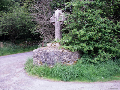
This stone cross is to be found in the Dublin mountains just above the town of Tallaght on the Ballinascorney pass. The cross stands on a junction of the old road to the Kilbride army camp and the newer road that leads towards Brittas (the R114). Like many antiquities it can be easily missed.
The cross unlike some of the others I have previously posted is not an ancient cross but a commemorative one built to mark those who died in the great potato famine which began in Ireland in 1847.
The cross is made of granite which is dominant among the hills of Dublin and Wicklow and stands a little under six feet tall and at it's widest, three feet. It has been placed upon a circular stone base giving it even more height. It is roughly dated to around 1850 and became a directional point for the way to the mass rock in the forest on the slopes of Ballymorefinn Hill approx 2KM away. Mass rocks were designated sites where during penal times almost 350 years ago Catholics celebrated mass in seclusion when mass was banned and any clergy found celebrating it risked being executed.
A small stone cottage ruin is situated in the trees on private ground just behind the cross. It is aptly called Stonecross cottage.
To find the cross take the R114 towards Ballinascorney from the crossroads at the old mill pub in Tallaght and drive for approx 4.5KM until you see a little slip road on your left (L7462). Drive up the slip road and the cross is at the top at he fork in the road. You can park on the grass verge opposite.
An impressive ruin on a country road in Haynestown Co. Louth, this more unusual looking castle is believed to date to the 16th century. It stands three storeys high with its main entrance now blocked up and situated on the ground level of the West side. A secondary entrance is also blocked up on the East side. Its main feature are the four large circular corner turrets two of which seem somewhat larger than the others and are on the West side. The original owners of the castle remain unknown and believe me I did my best to find out who they were but to no avail. The castle still appeared to be in use in 1784 as an antique print I came across depicts it with a wooden door and also a set of steps in the West side of the Northwest turret leading to a turret door. The turrets on the Northwest and Northeast appear on the print to be shown as degrading at that point so it may be a case of a slow decline into ruination over subsequent years. The 1837 Ordnance Survey map states that it is definitely in ruin by that time. Lewis's Topographical Dictionary of the same year describes the Castle details perfectly under the slightly different townland name of Heynestown but lists the name as Dunmahon Castle which in fact has squared turrets not circular and is a short distance away on private land near Gibstown.
Overgrown vegetation seems to have been the castle's worst enemy in latter years and although cleaned away previously it now appears to be gaining hold again. The turrets all appear to have lost some height over the centuries. I noted on our visit that this castle which contains a spiral stairs within would be a really good project for renovation, at least to the standard of unblocking the entrance, placing gravel ground inside and giving public access to see the interior and perhaps climb to the top of what is left of the Southeast turret.
The castle is adjacent to a Church of Ireland church built in 1803 and renamed from St. Nicholas' to St. Paul's when it was renovated in 1827. The location of both castle and church are on a small country road which was almost devoid of any passing traffic, at least while we were there. I attempted to navigate the base of the castle but was thwarted by the ever growing bushes. It still surprises me how many castle ruins are secreted away on country lanes but this one is worth seeking out and perhaps a further clean up may expose more of its features,
To find the ruins take the junction 16 exit of the M1 motorway and take the exit for the N52 to Dundalk off the roundabout. Drive for approx 220m and take the first left turn onto the L7165. Get into the right hand lane and turn right at the T-junction. This is a small loop road that takes you back onto the N52 so that you can access the next road you need which is across the dual carriageway. Turn right back onto the N52 and then a few metres further on turn left onto the continuation of the L7165 signposted for Haynestown. Drive approx 400m until you cross a small bridge over the rail line and turn right at the T- junction beyond it. Continue on for another 500m and straight through the crossroads. The castle and church are approx 320m along on your left hand side. There is ample room to park outside the church.
I had the pleasure of visiting Loftus Hall a few years back when the house tours were in full swing and it's sad to see that it has been recently sold and that public access is for now at least not possible. Hopefully this will be temporary and it will be open to public viewing again in the future.The previous owner Aidan Quigley who bought the hall when it was falling slowly into ruin and then built it up into a popular attraction has to be commended for his enterprise. The new owner has not been made public but Aidan has said that he hopes the hall will go on to bigger and better things.
The history of the hall began when in 1350 when it replaced a castle built in 1170 by Raymond Les Gros who came to Ireland during the Norman invasion. The new building was named Redmond Hall after its new occupants and it remained so until the plantation when the hall and lands were granted to Dudley Loftus. It then became commonly known as Loftus hall. The house was renovated in the 1870's on the premise that a royal visit would ensue, but this never came to pass and the costs incurred bankrupted the estate leaving the house to fall into disrepair. It was bought by a Benedictine order in the early 20th century and subsequently in 1937 became a convent school for the Sisters of Providence. It spent a short period in the 1980s and 1990s being renovated and operated as a hotel before closing by century's end leaving it again blocked up and deteriorating..
Of course the noteriety of the hall which sits on the windblown Western side of the Hook peninsula is its haunting. On the tour we were regaled with tales of severed hands, the forlorn ghost of Anne Loftus and the very Devil himself. The origin of the haunting is said to have been born in 1766 and has a few variants on the tale the most oft told being the following: Apparently the inhabitants welcomed in a stranger on a stormy night and later over a game of cards found they had invited not what seemed to be a lost soul but actually more like the goat of Mendes,(Satan to you and me). Anne Loftus on reaching down to pick up a dropped card saw the stranger's cloven hooves instead of feet and on letting out a shrill scream caused the stranger, his identity revealed, to exit the room through the roof in a ball of fire. Strangely this particular occurrence was mirrored in the Hellfire club in Dublin a number of years previously (see earlier post here). Ann Loftus was so distressed by the event that her family, unable to console her or regain her calm, had to lock her away in a room where she eventually died a year later still distraught and in the grip of madness. It is her ghost that is said to haunt the hall as disturbances and unexplained events began to occur following her death.
The haunting and other strange occurrences were recorded over the years by the different orders of nuns in the early 20th century and later by subsequent owners. The hall's use as a hotel failed and even on our visit no one was allowed on the upper floors which were still in bad disrepair and as reported very badly haunted. We were shown the great staircase of a type that was one of three built to that the design the other two being in the Vatican and on the ill fated Titanic. We also were taken to the tapestry room where Anne ended her living days and whether it be by subtle suggestion or actual evocation this was indeed a very unsettling room which caused the peripherals of my eyesight a lot of distress during my time in there.
For now many of the windows still remain blocked up, paper is peeling from the walls inside and there is a general sense of inner distress in the house almost palpable in some sections.
Paranormal investigations were allowed by the owners and indeed bore fruitful results. Loftus hall is without doubt haunted, be it by spirits or by tragedy. Regardless, its eerie stain will stay with you long after you have left its domain.
To find the hall take the R733 from Wellingtonbridge heading West and after approx. 8KM you will reach a crossroads with the R734. There is a large sign stating "Welcome to the Hook" and a road sign pointing left for Fethard. Turn left at the crossroads and follow the road until you enter Fethard, a pretty little seaside village. About halfway up the main street take the right hand turn just after the pharmacy and continue on this road for approx 1.6KM until you see the sign for Loftus hall on your right. The entrance gate is flanked by pillars. Hopefully these directions will have purpose again soon and a visit can be made.
Above Image: Exterior of constables tower
Originating in the 13th century Swords Castle was established after the Norman invasion. A structure and gatehouse probably constructed of wood had been evident here in the 12th century. A stone church was built on the site during the 13th century and is thought to have been inhabited by Archbishop Comyn. Subsequent buildings were added to the group and it evolved into the Archbishop's palace. It remained so until 1324 when in some state of disrepair after being damaged by the campaign led by Edward the Bruce, the Archbishops moved to a new palace in Tallaght.
The fine gatehouse, curtain walls with towers and the constables tower were added in the mid 1400's in a time of fortification that took place especially within the Pale due to ongoing attacks in the region.
The fortunes of the castle after this period are unclear but it seemed to have fallen into a ruinous state by the 19th century. It was bought by the Cobbe family in the 1870's and fell under the care of the OPW in 1930 until in 1976 Fingal Co. Council purchased the site in order to set about restoration but it took until 2012 for this to be realized and it was finally opened for public view in 2015.
The impressive curtain walls lend a sense of grandness to the group of structures dominating the South and East side.The entrance gate has two towers attached with spiral stairs within and on the opposite side of the courtyard is the constables tower.
As you walk through the gate the building on the left was the chambers for knights and squires while the Archbishops apartments lie beyond the church on the right. The remains of the great hall are on the far right towards the North tower. The council have also installed wooden steps and galleries for viewing purposes.
The castle has a dramatic impact upon the village of Swords and is well worth a visit in which you could also take in the nearby Sword's towers (see earlier post here).
The usual opening hours for the castle are as follows: 9.30am - 4.30pm daily except Mondays on which it is closed. Admission is free.
To find the castle take the junction 3 exit of the M1 motorway and at the top of the exit ramp take the first turn left onto the R125 signposted for Swords. Continue on this road straight through the next two roundabouts and again on the third thus joining the R836 for Swords. Continue straight through the village and you will see the gatehouse at the junction at the top of the road. Turn left here and a few metres down on the left you can park in the castle shopping centre car park.