Thursday, 30 August 2012

Moyry Castle Co Armagh


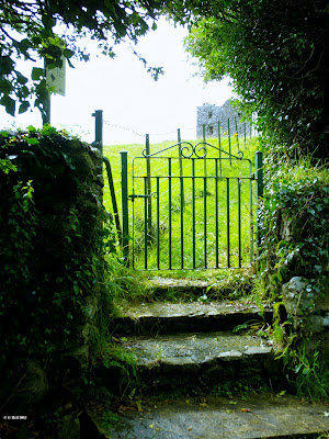
                                Above Image: The entrance gate from the road

                                             Below 4 Images: The interior


                                          Above Image: The entrance door


Moyry Castle was built by Lord Mountjoy on elevated ground at the Moyry Pass in 1601. Mountjoy had recently engaged in a battle with the O'Neills of Ulster which eventually ended in a stalemate. The Moyry Pass also known as The Gap of the North was an ancient route between the provinces of Leinster and Ulster and so was a very strategic location to erect a defencive Tower and Bawn.
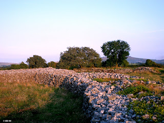
The Castle which stands three storeys high was surrounded by the aforementioned Bawn and had as defences a machiolation above the entrance door and gun loops in the walls. An unusual feature of this Castle are it's rounded walls. The Castle appears to have had rudimentary wooden floors with no evidence of stairs. This would lead one to believe that the floors were accessed by wooden ladders. It is thought that the Castle may not have been in use for very long and although the outer walls remain quite solid the interior is empty and the Bawn reduced to a small stretch about eight feet high which is located to the south east of the Tower.
Moyry is not difficult to reach. You will however have to drive down a by-road as it is a little off the beaten track. We manged to park outside the wall of a nearby house and walk back to the small iron gate that leads you into the Castle field. For a moment I stood and listened as there is the sound of a gurgling stream at this gate which when coupled with the vista of the ruins creates a very rustic and tranquil atmosphere.
A short walk up a grassy track leads you directly to the site. You can enter the Tower by the door facing you as you approach, but as mentioned it is just an empty shell inside. Partial remains of the Bawn sit adjacent and apparently this once square Bawn had the Tower situated at one of it's corners.
As you walk around the Tower you head down the hillock and this gives the ruins a far more imposing aspect. It is situated in a very scenic spot offering fine views that would have been in its time defensively crucial.
To find Moyry Castle, take the Junction 20 exit for Jonesborough from the N1 Dundalk to Belfast road. Drive through Jonesborough Village (B113) and take the first right hand turn at the Supermarket. A few yards on turn left onto the Kilnasaggart road. This road becomes quite narrow in places and you will need to drive approx. 2KM until you reach a fork in the road. Turn left and about 50 metres later you will see a small iron gate on your right. You can park a few metres further on near a house and just walk back toward the gate.

Thursday, 23 August 2012

Carlingford Abbey Co Louth


                                           Above Image: The machiolation


                         Above 2 Images: The adjacent ruin. Possibly a Mill House


                                     Above Image: The Eastern arched window


The picturesque town of Carlingford on the Cooley peninsula has many interesting structures to see including King John's Castle, Taafe's Castle, The Mint and The Thosel Gate. On the eastern end of the town you will find the ruins of the Dominican Abbey founded in 1305AD under the patronage of Richard De Burgo and dedicated to St. Malachy. It remained in use until it was dissolved under the suppression of Abbeys by Henry VIII in 1540. The Abbey went through further troubles when in the 1670's it found itself the subject of a struggle for repossession between the Dominicans and the Franciscans, the issue finally being resolved by Oliver Plunkett who deemed the Abbey to return to the Dominicans. Within a century they would abandon the Abbey and relocate the order to Dundalk.
While visiting King John's Castle on the Lough side we decided to also take a look at this Abbey as well. It is only a few minutes walk up through the town and it can be accessed at it's entrance on the corner of Dundalk Street and Abbey Court. What remains today are the nave, the chancel and the central belfry tower. Slightly south and adjacent to the Abbey are the ruins of what may have been domestic quarters or possibly a Mill house.
The Abbey with it's long narrow design has a fortified look about it. The entrance aspect on the western facing side resembles a Castle tower house and indeed there even appears to be a machiolation high above the doorway. This would allow the occupiers to cast rocks or boiling liquids down upon potential attackers.
The central tower is supported by a pointed archway which gives full view to the large arched window on the eastern facing side. The upkeep of the site is very good and the remaining walls seem solid enough to last another 700 years. The Abbey has a striking look about it inside and is frequently utilized as a backdrop in many local wedding photos.
Architecturally the ruins are very pleasing to the eye but unfortunately there are no nooks and crannies to explore. Nonetheless it is an impressive structure and worth seeing if you happen to be in the area.
To find Carlingford Abbey, take the R173 eastwards from the M1 at Dundalk and drive until you reach Carlingford. This road automatically becomes Dundalk Street in the town. Keep looking to your right and you will eventually come across the Abbey. Parking can sometimes be difficult in the town, we parked easily by the loch side and just walked up the short distance to the Abbey.

Sunday, 19 August 2012

The Ring Of Rath Co Wicklow


                            Above Image: Aerial view of the site.  © Google Maps


                                         Above Image: The roadside entrance

                                    Above Image: The wooden stile
                                    Below Image: The Ditch entrance (3rd Ring)


                                        Above Image: Some of the stonework


                         Above Image: Remnants of the 4th Ring on the perimeter


                            Above Image: One of the chambers seen from above

                                             Above Image: The Fairy Tree


Situated east of Tullow and covering an area of approx. 18 acres is one of the most impressive stone hill forts in the country. It is called Rathgall but is known locally as The Ring of Rath. Comprising of four rings, the inner three being circular stone ramparts with the innermost constructed at a later date than the others, this site is just amazing to view.
Dated to the Bronze Age circa 800BC it was excavated in 1969 and a fair amount of artefact's were uncovered making this historically an extremely important site. Evidence of Bronze Age smelting and dwellings were also discovered. The innermost ring is thought to have been added in medieval times when the fort was still in use. It is believed to have been unoccupied for up to a thousand years after it's initial use and it is debated that it might be a possible site of the seat of the Kings of Leinster or indeed a burial site for same.
For such a large construction it is not really that visible from the road. Ariel views easily confirm it's actual size. The walls are surrounded by an outer ditch but access is granted by the landowner by way of a track that is perimetered by fencing. Care is required here as some of the fencing is electrified being that there are cattle in the adjacent fields. The fort itself is often used for grazing purposes.
We arrived on an early Autumn evening not really knowing what to expect but I can assure you that we would never have imagined just how extensive this fort is. Once through the entrance at the ditch, the walls inside stand  up to 6 feet high and in places 12 feet thick!. It is possible to climb up onto the top of the walls although they are somewhat ruinous with a lot of stones displaced but you can still circumnavigate, especially on the inner ring. From this vantage point you can take in the full extent of the innermost two rings and it is amazing to think that it stretches further still. The diameter of the inner ring alone is 45 feet and in a couple of places on this ring it appears that there were chambers of some sort in the walls.
Being Pre-Christian this would no doubt have been a very important site and there were probably many Pagan burials that took place here.
The fort has long been the subject of folklore, from tales of people staying the night there in an effort to increase fertility to tales of mysterious disappearances within the rings. There is a curious tree standing close to the south east edge of the 2nd ring that legend has it that it is a Fairy tree and these not altogether friendly mystical folk inhabited the fort during it's human unoccupancy. The tree it is said was never removed for fear of reprisals. This may sound preposterous but in early times long before electric light banished all rustic mystery, people lived in dread of these creatures fearing abduction or worse. I can still recall part of an old rhyme penned by William Allingham that goes:
                                                      "Up the airy mountain,
                                                       down the rushy glen,
                                                       we dare not go a hunting,
                                                       for fear of little men"
We spent a good hour enjoying the marvels of Rathgall and I would recommend taking your time to properly take in what it offers. After all, at an age of approx 2800 years it is nearly as old as the Egyptian pyramids.
As we were leaving the landowner appeared ushering a herd of young cows which he was attempting to lead to the fort to graze. He told us that due to recent bad weather the cows had been fed in a barn and so on this fine evening he wanted them to graze on the grass in the fort to increase protein, but he seemed to be having a difficult time getting them to go in. "Typical," he said as we passed " They wont go the way that you want them to, it's this place, there's Fairies in there you know....."
To find The Ring of Rath take the N81 to Tullow and in the town turn onto the R725 towards Gorey. Drive for approx. 2KM where you will come across a fork in the road. Head down the left hand road and drive for approx. 1KM. You will come across a wide gate to the right with the fort signposted. You can park at the gate and still allow access for the landowner should he need it.

Saturday, 11 August 2012

Ballycowan Castle Co Offaly


                                          Above Image: The entrance stile


                               Below 2 Images: The Vaulted chambers beneath


The ruins of Ballycowan Castle with it's tall striking chimneys stand loftily on elevated ground overlooking the Grand Canal  a few miles west of Tullamore. The large fortified house was constructed in 1589 by Thomas Morres on the site of an earlier Castle belonging to the O'Molloys which was gutted by fire in 1557.
The new Castle was extended upon by Jasper Herbert in 1626 and the Herbert coat of arms can still be seen on one of the gable walls.
The Castle's South West walls were destroyed during an attack by Cromwellian forces and the lands were handed over to the English crown and subsequently granted to the Earl of Mountrath in 1666.
The four storey Castle contains vaulted ceilings on it's ground floor rooms and mullioned windows are very much in evidence. The defences of the Castle included a machiolation above the entrance and a bartizan at its North east corner.
The Castle is accessible at two points. The section with the entrance door and evidence of a Bawn lies within a farmyard. There doesn't deem to be much Human activity there but it would be wise to seek permission first.
The other section lies in an open field beside the Tullamore River which runs under the canal. You need to walk down the old Canal towpath as far as the stone bridge. Just before this bridge there is a slope leading down to some scrub on the right. Here almost hidden out of view is a fence with rudimentary stile which is not too difficult to cross. There is a sign which states reserved for gun club (as was with Srah Castle, not too distant) but nothing forbidding entry. Once in the field you will find it overgrown and stony underfoot in places. Some of these grass covered rocks are more likely to be rubble from the Castle. There also appears to be a Bull in the field but he was at a reasonable distance on our visit and seemed indifferent to our incursion.
 A slightly steep climb to the ruins in which care is recommended as the the long grass can be deceptive of what lies beneath, gives you access to the sunken floor of the Castle. Entry is through a gap in the wall. Within are two chambers with their barrel vaulted ceilings. There is another gap in the wall here leading to a third chamber but it has been somewhat shored up with rubble probably for safety reasons.
It's a great place to climb around and has a really creepy atmosphere within the vaulted rooms. There are probably more rooms to discover by way of the entrance on private land but that's for a future visit.
To find the ruins, take the R443 out of Tullamore towards Rahan. About a mile or so on you will reach a roundabout. Turn Left. Drive for approx. 2 miles until you reach  a left hand turn with a bungalow at it's corner  just before the main road takes a sharp bend right. Turn left by the bungalow and drive until you reach the bridge crossing the Canal. You can park your car on the immediate part of the towpath but be careful not to obstruct any gates.