Sunday, 27 November 2022

St. Fintan's Church & Antiquities Clonenagh Co Laois


                                             Above Image: The Entrance gate

                                                Above Image: Western window

                                      Above Image: Central arch and East window


                                              Above Image: West window interior

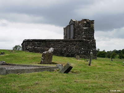
                                               Above image: Northern aspect


                                      Above Image: Gate to Catholic graveyard

                          Above Image & 2 Below Images: Early Christian grave slabs


                                              Above Image: Tree site of old well


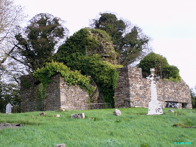
The ruins of this medieval church can be easily spotted from the R445 and were striking enough to draw us off the road from our journey towards Mountrath.

The site upon which the ruins lie is of some significance as this was the ancient site of the monastery of Clonenagh founded by St. Fintan in the mid 6th century. St. Fintan was a protege of St. Colum of Terryglass, Co Tipperary and is said to be buried at Clonenagh. The legendary literary work known as "The book of Clonenagh"  written in the monastery disappeared sometime during the English invasion and is thought to have been passed down clandestinely through the years, now residing privately in God knows what part of the world.

The monastery at Clonenagh was known to be somewhat austere in its practices but nonetheless flourished. It came under attack by the Danes in 838AD but was not totally destroyed and managed to survive to some degree until the Cromwellian invasion some 800 years later. The The church remains extant today were ruinous by the late 16th century but were adapted into a protestant place of worship during the plantation surviving with partial repairs until the 1840's when the church finally fell out of use. The graveyard surrounding the ruins contains internments of parishioners of the Church of Ireland.

The church measures approx. 27 feet x 27 feet consisting of part of the nave and a chancel with dividing arch.

We found entry by a rather stiff metal gate in the Western wall although had this not opened there was also access by a stile in the wall. The ruins are situated on elevated ground and the area below them is maintained. Several barriers have been placed at entry points which can be moved to gain entry. Within, although at least on our visit, it was quite overgrown and this might have been deemed a safety hazard so tread carefully if you decide to enter. The archway is the most impressive feature although the damaged East window is also of some note, otherwise it is pretty much a featureless shell.

A few yards opposite on the North side of the road from the ruins is another ancient Catholic graveyard surrounded by a wall but easily entered by a small iron gate held closed by a loose chain. Although the graveyard offers no extant ruins it does however contain a number of early Christian grave slabs which have been set against the boundary wall just to the left inside the gate. These date between the 7th and 11th centuries and were discovered at this site during a renovation in 1988. To the right of the entry gate of this graveyard was the site of a holy well which was covered up by the landowner in the 19th century as too many people were trespassing on his land and often unsocial behaviour would erupt. Legend has it that after the filling in of the well  St. Fintan rose the water up through the hollow of a sycamore tree, the remains still visible today. The majority of the tree was damaged and fell during a bad storm in the early 1990's but subsequently fresh shoots emerged miraculously from the stump. St. Fintan's influence still at work?

To find the ruins at Clonenagh, take exit 18 of the M7 motorway and off the roundabout follow the R445 towards Mountrath. Drive approx. 3KM  and you will pass over the M7 below. Continue another 2.5KM driving through a small crossroads with the L5675 and a short distance on there is a small crescent shaped pull in on the left at the site of the graveyard where you can park. The Catholic graveyard with the grave slabs is situated a few metres back on the right hand side again with a crescent shaped pull in so you can park easily.

Saturday, 8 October 2022

Bulloch Castle Co Dublin


                                               Above Image: Southern aspect

                                  Above Image: Approach road and Western aspect


                                                 Above Image: Eastern aspect

                                Above & Below Images: View from across the harbour


                             Above Image: Artist's Impression of castle buildings 1791


This early Irish castle is believed to have been constructed in the 12th century by an order of monks from St. Mary's abbey. The purpose of the castle was as storage and to protect the fishing activity from attacks by the Wicklow clans. A subterranean ice house was built to store the fish levied by the monks for the protection given to the fishing boats. The small village grew around the harbour and various walls and observation towers were added to defend the it

In 1539 the castle fell foul of the dissolution imposed by Henry VIII and became a property of the crown. A series of residents subsequently inhabited the castle including one John Watson (not Sherlock's friend) who in the 18th century added a domicile to the castle and was known to be very charitable. In 1818 a new pier was built in the harbour which is still in use to this day.

The castle and grounds were purchased in the last century by an American Carmelite order and in 1965 they opened the nursing home which still operates today. The ancillary buildings around the castle were demolished leaving the fine tower solely overlooking the harbour.

We took a drive out there recently knowing that the castle is not open to public view but that really only extends to the interior. You are perfectly welcome to view the castle up close from the car park of the home. Bulloch Harbour is pleasantly scenic and the castle adds a really striking focal point. It stands four storeys high and is almost rectangular in shape with a central building between the two towers. The harbourside tower has an archway which is open and divides the car park. This leads into the former courtyard and is a very narrow drive through!

To find the castle take the left hand turn from the Blackrock bypass onto the R119 towards Monkstown. Take the left hand fork of the road divided by the impressive Monkstown C of I church and continue on the R113 towards Dun Laoghaire. Follow on through Dun Laoghaire, Glasthule and Sandycove until you see the castle on your left hand side. We found a parking spot on Breffni Road just before the castle and had no problems. 


Sunday, 28 August 2022

Clonony Castle Co Offaly


                                                  Above Image: Entrance gate

                                           Above Image: Steps to courtyard gate


                                           Above 2 Images: Ground floor interior

                                                    Above Image: Spiral stairs

                                           Above Image: View of bawn from first floor


                                       Above 2 Images: Interiors from upper floors

                                                      Above Image: Courtyard

                                                Above Image: Ruins of kitchen

                                            Above Image: Boleyn grave marker

                             Above Image: Printed text of engravings on grave marker


The sturdy and very striking castle of Colony towers over its surrounds and is probably the finest testament to the MacCoghlan's who constructed it during the 1490's. They also built nearby Coole castle which I visited recently (see earlier post here).

The castle stands three storeys in height and has partial remains of ancillary buildings attached. There are ruins of a kitchen and a chapel.

The history of the castle is particularly interesting because of its associations to the Boleyns of Tudor history. It was seized as an asset by Henry VIII in the early 16th century and was later given with its lands to the newly appointed Earl of Ormond, Thomas Boleyn It was a crafty move by Henry to gain Boleyn's daughter Anne as his bride, as she would now hold a position appropriate for a King to marry. Of course the best laid plans went awry later when Anne met the blade of the axeman. Following this event it was thought wise to relocate her cousins Elizabeth and Mary to the safety of Clonony castle in Ireland where they would eventually live out their lives. Elizabeth died quite young and it is said that Mary threw herself from the parapets in grief of her loss. In 1603 when land was being quarried near the castle, a cave was found and within it were the remains of two bodies with a stone slab declaring their place of burial. These were identified as those of the Boleyn girls. The bodies were supposedly later buried in the grounds of Gallen priory but the grave marker was placed under a hawthorn tree back in the grounds of the castle where it can be seen today.

During the reign of Elizabeth I the castle was owned by Matthew De Renzi who became something of a Gaelic scholar more so to keep ahead of the local Gaelic speaking MacCoghlans who resented him as an interloper and the fact he lived in a former MacCoghlan stronghold. De Renzi is attributed with compiling the first English - Irish dictionary.

Some conservation work was done on the castle in 2010 and restoration within has also been lovingly achieved by its current resident Rebecca Armstrong, a former ballerina from the United States. When we visited we had hoped to meet Rebecca but she was away from home that morning. We were however greeted by a friendly chap named Adam James who has been landscaping the garden and bawn area and was only too happy to show us around and tell us the history.

Once you enter through the impressive gate  from the roadside the castle comes into full view standing proudly on its rocky outcrop. A series of well worn steps lead up to the courtyard gate and the entrance to the tower. Within, on the ground floor, is a fine library with a large table and the walls depict the castle history through paintings and prints.

The upper floors are accessed by a narrow stone spiral stair bringing you to the living quarters where much of the restoration has taken place. The top floor and parapets are apparently haunted by a ghost in full armour. Is there not a castle in Offaly without its ghosts?

The courtyard area still remains ruinous and contains amongst others a former castle kitchen. There is also a very visible machicolation above the entrance door which is in the West wall.

All in all a very impressive structure and definitely worth visiting. The future of the castle being open for public visits will depend on the new owners as Rebecca has decided to move on (maybe to another project) so if you intend to visit use the contact details below to ask about access.

The castle is normally open during the summer months Friday - Sunday 12pm-5pm or otherwise by appointment. Contact +353877614034.

To find the castle take the junction 8 exit of the M6 and follow the signs for the N62 to Birr. Continue on the N62 through Ferbane until you reach Cloghan where you take a right turn onto the R357 toward Shannonbridge. Drive approx 3.5KM and you will see the castle bawn wall on your right. There is a small parking area just past the castle entrance gate. If the castle is open there is usually a sign hung up outside.


Friday, 12 August 2022

Old Palmerstown Church Oldtown Co Dublin


                                  Above Image: Corner of East and North walls


                                           Above Image: Inner Entrance gates


                                   Above Image: Corner of North and West walls


                                          Above Image: Section of North wall


Very little remains of this small medieval church which lies in the Northwest corner of the County of Dublin. 

The church which is recorded as being once under the auspices of St. John the Baptist priory was probably constructed in the 12th or 13th century. It was more than likely a small parish church or chapel of ease and has not withstood the sands of time very well. After the dissolution in the 16th century a lot of small churches fell into disrepair and ruin as the community had no means to maintain their upkeep and this appears to be one of them. 

The ruins are situated on elevated ground within a walled enclosure which is from a later date. The site is accessible from a country road through two sets of gates.  The inner gates are part of the actual enclosure which is based in farmland. Among the gravestones the East and West gables exist only at foundation level with the North and South walls barely over a foot high. A great deal of work is happening on a continual basis to keep the graveyard clean and it is commendable. It's a shame that the church has been reduced to the level it is but efforts are being made to inhibit any further loss.

The earliest inscribed marker here dates to 1774 and there is a well also dedicated to St. James in a field to the South.

Point of note, parking at the roadside gate is precarious. There is only a small tarmac area which is slanted down from the gate leaving your car parked at an odd angle. There is also a bend in the road just prior to the gate so be very aware before open the door and step out.

To find the ruins take the junction 3 exit from the M2 and at the Nine Mile roundabout take the third exit onto the R125 towards Swords. Drive approx. 700m until you reach a junction with the L5019. Turn left here and then immediately right onto the L5022-9. Continue on this road for approx. 500m where the road bends sharply right and then left. Continue straight on approx. 900m to the next sharp right bend and 300m farther on is the gate to the graveyard on your left.

Sunday, 17 July 2022

Coole Castle Co Offaly


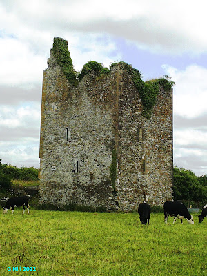
                                             Above Image: North & West aspects.


                                            Above Image: West & South aspects

                                       Above Image: The guardians of Coole Castle.


Having not been out in County Offaly for a while it was great to take in a bit of ruin hunting!

Just East of the village of Ferbane in the barony of Garrycastle and parish of Wheery on a country lane leading down to the Brosna River is the site of Coole Castle a 16th century stronghold built in 1575 as a gift to his second wife by Sir John MacCoghlan member of a very prominent family in this area.

The castle, a three storied tower house was completed, according to a engraved plaque inside, in 1575 after a couple of years of interrupted construction. An entrance door was placed on the East side while the South side had a commanding view of the river. 

Sir John bequeathed the castle in his will to his wife Sabina O'Dallachain in 1590. It is thought to be one of the many castles destroyed or damaged badly by the English forces following the confederate wars and subsequent Cromwellian invasion. The family name however remained very influential both in the area and in the English parliament as far as 1790 and beyond.

There is only one real access route to the castle unless you have a row boat! A twisty country lane brings you literally down to a narrow bridge at the river and the castle is in a meadow near the road with a small rather beaten up metal pedestrian stile for access. Even though access to the interior is not possible and the upper floor has been damaged badly it is still a very commanding tower and worth a look. After all it is a listed building. The meadow is used for grazing cows and these ladies were very inquisitive but friendly following us around.

The castle has a legend, and we all love a legend, that there is an earthenware pot of gold hidden under a rock somewhere in the castle but it is protected by a spirit who will go to no ends to retain it. So if you find the gold be prepared to bring something else home with you!

To find the ruins take the junction 8 exit from the M6 motorway onto the N62 (first left off the exit roundabout). Drive straight on through the next roundabout following the N62 to Birr. Continue on the N62 until you reach Ferbane. Once on the Main Street take a left at the small crossroads in the village following the R436 to Kilbeggan. Drive approx 600m and turn at the first right hand turn onto the L30048. Follow this winding little road all the way to the bottom (passing Kilreahan cemetery) and you will see the ruins on your left. You can park just before the footbridge at the castle field gate.

Monday, 6 June 2022

Old Balfeaghan Church Co Meath


                                                  Above Image: Entrance gate 

                                               Above Image: Outer East gable

                     Above Image: Inner East gable and partial South wall in foreground


                       Above Image: Portions of the North (foreground) & South walls

                                     Above Image: Fragments within the enclosure.


The ruins of this small parish church are situated in a bucolic setting along the Kilcock to Summerhill road. The parish was created around 1250AD and the small church named after St. Feighin (who may have been St. Feichin of Fore) is thought to have been constructed shortly thereafter. Measuring at approx 44 feet x 16 feet, it appears to have been a single cell structure with no divisions inside. The church may also have been built as a chapel of ease for locals for whom the bigger parish church was a fair distance away. When the abbey at Trim was suppressed in 1540 this small church was listed as a possession and so it too was taken out of use. The church was historically recorded as being in total ruin by 1682.
Access to the site today is easy by way of a metal gate or stone stepped stile into a grassy enclosure which is rectangular in shape. The ruins lie on the crest of a small sloped elevation with the East gable being the most prominent remains. Corner sections of both the North and South walls still remain but the West wall is non-extant although it's position is defined by the slope on that side of the elevated ground.
Around the 1830's a low wall enclosure was built out of the East gable and now houses memorial stones set against the inner wall. Within this enclosure are also to be found a few stone fragments from the church which include part of it's original font and stone window surround. There are no further features extant.

To find the ruin take the R148 from St. Coca's church in Kilcock and approx 800m along take the right hand turn signposted for the R158 to Trim and Summerhill. Drive approx 600m, crossing the River Rye and arriving at a small roundabout. Continue straight on through the roundabout and approx 200m on your right you will see the cemetery. You can park easily at the entrance gate.


P.S.  Please also find an update to the Ballymount Castle post (here)